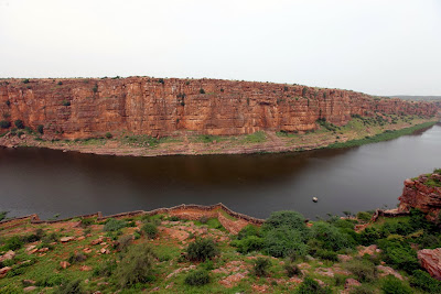
Gandikota is a small village on the right bank of the river Pennar, 15 km from Jammalamadugu in Kadapa district founded in 1123 by Kapa Raja.
The fort of Gandikota acquired its name due to the 'gorge' (in Telugu it is called 'gandi'), formed between the Erramala range of hills, also known as Gandikota hills and the river Pennar that flows at its foot, reducing its width to a mere 300 ft (see the river image below). Situated amidst beautiful landscape and wild forests, it is endowed with vast natural resources.
The fort was made more impregnable by Pemmasani Thimma Nayudu. The fort was under the control of Pemmasani Nayaks for over 300 years.
It was late in the evening when I reached the APTDC Hotel, Haritha. I breathed a sigh of relief since the 10 km drive from Jammalamadugu to Gandikota was one of the scariest drives of my life. Pitch dark, an eerie chill, inconsistent zig-zag roads, no warning signs, no signs whatsoever, tiny turning points and a horizon that felt like abyss. I really thought I am going nowhere.
 |
| Belum Caves |
The first light was not rising sooner than I wanted, unfortunately for me; the clouds were holding it back. I needed this light and sky to be clear for my shoot and it wasn’t looking good.
I wasn’t too far from my hypothesis about the horizon…far, till really far, far, away from my vintage point all I could see only a small patch of grey-green texture between the blank sky and very solidly and widely spread fort bastions.
 |
| The Jamia Masjid |
 |
| Remains of the Raghunathaswamy temple |
 |
| Entrance to the fort |
 |
| Pigeon Tower |
 |
| Penna Gorge and the fort bastions |
 |
| River Penna and it's flow |

No comments:
Post a Comment